Patuha topographic map
Interactive map
Click on the map to display elevation.
About this map
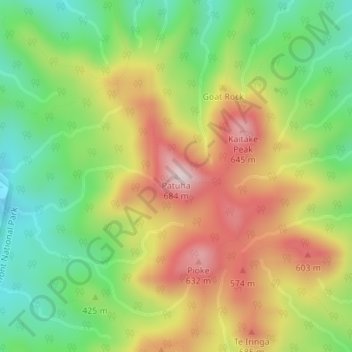
Name: Patuha topographic map, elevation, terrain.
Location: Patuha, New Plymouth District, Taranaki, 4314, New Zealand (-39.16136 173.96563 -39.16126 173.96573)
Average elevation: 413 m
Minimum elevation: 218 m
Maximum elevation: 648 m
Other topographic maps
Click on a map to view its topography, its elevation and its terrain.
The Peak
New Zealand > Taranaki > New Plymouth District
The Peak, New Plymouth District, Taranaki, New Zealand
Average elevation: 305 m
Brooklands Park
New Zealand > Taranaki > New Plymouth District > New Plymouth
Brooklands Park, Brooklands, New Plymouth, New Plymouth District, Taranaki, New Zealand
Average elevation: 52 m
New Plymouth
New Zealand > Taranaki > New Plymouth District
New Plymouth, New Plymouth District, Taranaki, 4310, New Zealand
Average elevation: 92 m
Waitara
New Zealand > Taranaki > New Plymouth District
Waitara, New Plymouth District, Taranaki, 4320, New Zealand
Average elevation: 28 m