
Make a donation
Gear up for your next adventure:
As an Amazon Associate, this site earns from qualifying purchases at no extra cost to you.
Hankavan topographic map
Click on the map to display elevation.
Make a donation
Gear up for your next adventure:
As an Amazon Associate, this site earns from qualifying purchases at no extra cost to you.
About this map
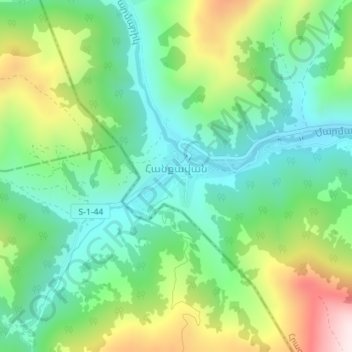
Name: Hankavan topographic map, elevation, terrain.
Location: Hankavan, Hrazdan region, Kotayk Province, Armenia (40.63109 44.47793 40.63714 44.49290)
Average elevation: 2,124 m
Minimum elevation: 1,941 m
Maximum elevation: 2,492 m
Make a donation
Gear up for your next adventure:
As an Amazon Associate, this site earns from qualifying purchases at no extra cost to you.
Other topographic maps
Click on a map to view its topography, its elevation and its terrain.
Hrazdan
Armenia > Kotayk Province > Hrazdan
Hrazdan has an average elevation of 1,675 meters above sea level. The town has a warm-summer humid continental climate (Köppen climate classification Dfb).The average temperature is 6 °C (ranging from -7 °C in January to 18.1 °C in August). The annual precipitation is around 700 mm.
Average elevation: 1,825 m
Make a donation
Gear up for your next adventure:
As an Amazon Associate, this site earns from qualifying purchases at no extra cost to you.
Make a donation
Gear up for your next adventure:
As an Amazon Associate, this site earns from qualifying purchases at no extra cost to you.
Make a donation
Gear up for your next adventure:
As an Amazon Associate, this site earns from qualifying purchases at no extra cost to you.