
Make a donation
Gear up for your next adventure:
As an Amazon Associate, this site earns from qualifying purchases at no extra cost to you.
Texada Island topographic map
Click on the map to display elevation.
Make a donation
Gear up for your next adventure:
As an Amazon Associate, this site earns from qualifying purchases at no extra cost to you.
About this map
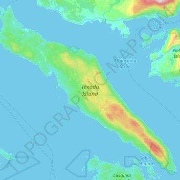
Name: Texada Island topographic map, elevation, terrain.
Average elevation: 83 m
Minimum elevation: -1 m
Maximum elevation: 1,268 m
Make a donation
Gear up for your next adventure:
As an Amazon Associate, this site earns from qualifying purchases at no extra cost to you.
Other topographic maps
Click on a map to view its topography, its elevation and its terrain.
Mount Shepherd
Canada > British Columbia > qathet Regional District > Area D (Texada Island)
Average elevation: 558 m
Van Anda
Canada > British Columbia > qathet Regional District > Area D (Texada Island)
Average elevation: 49 m
Gillies Bay
Canada > British Columbia > qathet Regional District > Area D (Texada Island)
Average elevation: 53 m