
Homburg topographic map
Interactive map
Click on the map to display elevation.
About this map
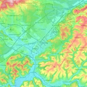
Name: Homburg topographic map, elevation, terrain.
Location: Homburg, Saarpfalz-Kreis, Saarland, 66424, Duitsland (49.24742 7.27372 49.38637 7.40483)
Average elevation: 284 m
Minimum elevation: 214 m
Maximum elevation: 447 m
Other topographic maps
Click on a map to view its topography, its elevation and its terrain.
Gersheim
Duitsland > Saarland > Saarpfalz-Kreis
Gersheim, Saarpfalz-Kreis, Saarland, 66453, Duitsland
Average elevation: 303 m