
Neureuth topographic map
Interactive map
Click on the map to display elevation.
About this map
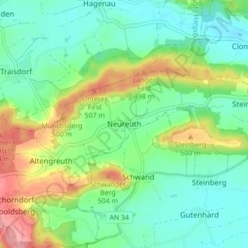
Name: Neureuth topographic map, elevation, terrain.
Average elevation: 459 m
Minimum elevation: 426 m
Maximum elevation: 528 m
Other topographic maps
Click on a map to view its topography, its elevation and its terrain.
Schlosspark Schillingsfürst
Deutschland > Bayern > Landkreis Ansbach > Schillingsfürst > Stilzendorf
Schlosspark Schillingsfürst, Schafhofsteige, Stilzendorf, Schillingsfürst, Schillingsfürst (VGem), Landkreis Ansbach, Bayern, 91583, Deutschland
Average elevation: 489 m