Geolocate

Plön topographic map

Click on the map to display elevation.

About this map
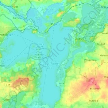
Name: Plön topographic map, elevation, terrain.

Location: Plön, Kreis Plön, Schleswig-Holstein, 24306, Germany (54.08196 10.33037 54.17965 10.49508)

Average elevation: 34 m

Minimum elevation: 15 m

Maximum elevation: 91 m

Other topographic maps

Click on a map to view its topography, its elevation and its terrain.
Heidkate

Germany > Schleswig-Holstein > Kreis Plön > Wisch

Average elevation: -1 m

Gear up for your next adventure:

🧢Thermal Beanie Hats - Prevent heat loss from the head in windy summit conditions
🧦Hiking Socks - Breathable socks designed to prevent blisters on long walks
🎒Hiking Backpacks - Comfortable backpacks for day hikes and multi-day treks
🔋Solar Power Banks - Keep your GPS and phone charged during multi-day expeditions
🔋Lithium AA Batteries - Long-lasting power that performs well in cold mountain weather

As an Amazon Associate, this site earns from qualifying purchases at no extra cost to you.