
Caneda topographic map
Interactive map
Click on the map to display elevation.
About this map
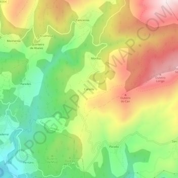
Name: Caneda topographic map, elevation, terrain.
Average elevation: 358 m
Minimum elevation: 70 m
Maximum elevation: 691 m
Other topographic maps
Click on a map to view its topography, its elevation and its terrain.
Painceiros
Espagne > Galice > Pontevedra > Campo Lameiro
Painceiros, Moimenta, Campo Lameiro, Pontevedra, Galice, 36110, Espagne
Average elevation: 454 m