Geolocate

Réunion topographic map

Interactive map

Click on the map to display elevation.

About this map

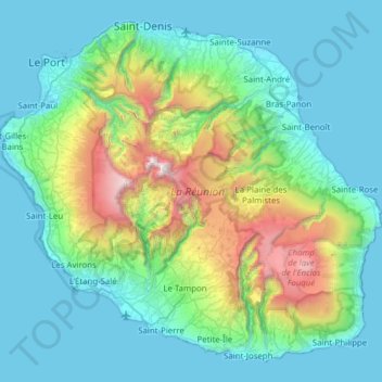
Name: Réunion topographic map, elevation, terrain.

Location: Réunion, France (-21.38973 55.21643 -20.87171 55.83669)

Average elevation: 532 m

Minimum elevation: 0 m

Maximum elevation: 3,043 m

Other topographic maps

Click on a map to view its topography, its elevation and its terrain.

Sainte-Rose

France > Réunion

Sainte-Rose features a tropical rainforest climate (Köppen Af), with substantial rainfall throughout the course of the year. Its location on the eastern side of Réunion, (windward relative to the trade winds), makes it one of the wettest cities in the world, along with Cherrapunji, Quibdó, and López de…

Average elevation: 505 m

Saint-Benoît

France > Réunion

Average elevation: 561 m

Saint-Denis

France > Réunion

The city is located on the north end of the island, and was a port. Saint-Denis was "originally the main port of Réunion, but an artificial harbour at Le Port, on the northwest coast, replaced it in the 1880s, because of unpredictable winds and tides at Saint-Denis." The city includes some of the island's…

Average elevation: 722 m

échelles

France > Réunion > Saint-Benoît

Average elevation: 1,008 m

Réunion

France > Réunion

Already at the time of the India Route or Route des Indes, Réunion was a French possession located between Cape Town and the Indian trading posts, although far from the Mozambique Channel. Île de Bourbon (its name under the Ancien Régime) was not, however, the preferred position for trade and military.…

Average elevation: 532 m

Marla

France > Réunion > Saint-Paul > Marla

Average elevation: 1,798 m

Hell Bourg

France > Réunion > Hell Bourg

Average elevation: 1,132 m

Cayenne

France > Réunion > La Possession > Cayenne

Average elevation: 916 m

Saint-Leu

France > Réunion > Saint-Leu

Average elevation: 360 m

Saint-Benoît

France > Réunion > Saint-Benoît > Saint-Benoît

Average elevation: 50 m

Terre Sainte

France > Réunion > Saint-Pierre > Terre Sainte

Average elevation: 50 m

La Petite Ferme

France > Réunion > Le Tampon > La Petite Ferme

Average elevation: 1,522 m

Caverne Dufour

France > Réunion > Salazie

Average elevation: 2,217 m

Le Tampon

France > Réunion > Le Tampon

Average elevation: 1,005 m

Le Port

France > Réunion > Le Port

Average elevation: 25 m

La Réunion

France > Réunion

Already at the time of the India Route or Route des Indes, Réunion was a French possession located between Cape Town and the Indian trading posts, although far from the Mozambique Channel. Île de Bourbon (its name under the Ancien Régime) was not, however, the preferred position for trade and military.…

Average elevation: 532 m

Saint-Pierre

France > Réunion > Saint-Pierre

Average elevation: 327 m

Cap Blanc

France > Réunion > Saint-Joseph

Average elevation: 1,176 m

Saint-André

France > Réunion > Saint-André

Average elevation: 125 m

Saint-Paul

France > Réunion

Average elevation: 466 m

Saint-Philippe

France > Réunion > Saint-Philippe

Average elevation: 663 m

La Possession

France > Réunion > La Possession

Average elevation: 605 m