Geolocate

Corvallis topographic map

Click on the map to display elevation.

About this map

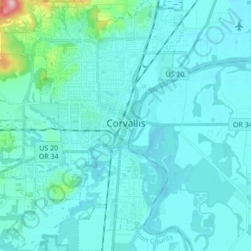
Name: Corvallis topographic map, elevation, terrain.

Location: Corvallis, Benton County, Oregon, United States (44.51993 -123.33622 44.60724 -123.23104)

Average elevation: 81 m

Minimum elevation: 57 m

Maximum elevation: 324 m

Other topographic maps

Click on a map to view its topography, its elevation and its terrain.

Alsea

United States > Oregon > Benton County

Average elevation: 154 m

Coast Range

United States > Oregon > Benton County

Average elevation: 824 m

Kings Valley

United States > Oregon > Benton County

Average elevation: 125 m

Forest Peak

United States > Oregon > Benton County

Average elevation: 385 m

Gear up for your next adventure:

🔥Emergency Fire Starters - Reliable ignition tools for survival situations in damp conditions
👟Women's Trail Running Shoes - Agile footwear for fell running and technical trails
GPS Outdoor Watches - Watches with GPS tracking for hiking and exploration
🌦️Portable Weather Meters - Handheld tools for monitoring weather conditions
👕Merino Base Layers - Natural temperature regulation for cold weather hiking and camping

As an Amazon Associate, this site earns from qualifying purchases at no extra cost to you.