
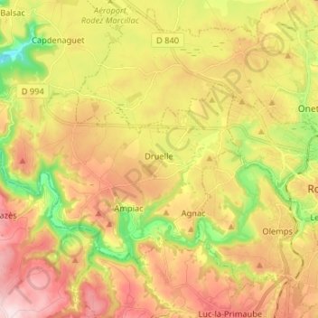
Druelle topographic map
Interactive map
Click on the map to display elevation.
About this map
Name: Druelle topographic map, elevation, terrain.
Average elevation: 592 m
Minimum elevation: 409 m
Maximum elevation: 763 m
Other topographic maps
Click on a map to view its topography, its elevation and its terrain.
Balsac
France > Occitanie > Aveyron > Druelle Balsac
Balsac, Druelle Balsac, Rodez, Aveyron, Occitanie, France métropolitaine, 12510, France
Average elevation: 514 m
Agnac
France > Occitanie > Aveyron > Druelle Balsac
Agnac, Druelle Balsac, Rodez, Aveyron, Occitanie, France métropolitaine, 12510, France
Average elevation: 581 m
Les Planques
France > Occitanie > Aveyron > Druelle Balsac > Druelle > Les Planques
Les Planques, Druelle, Druelle Balsac, Rodez, Aveyron, Occitanie, France métropolitaine, 12510, France
Average elevation: 565 m