
Make a donation
Gear up for your next adventure:
As an Amazon Associate, this site earns from qualifying purchases at no extra cost to you.
Montreux topographic map
Click on the map to display elevation.
Make a donation
Gear up for your next adventure:
As an Amazon Associate, this site earns from qualifying purchases at no extra cost to you.
About this map
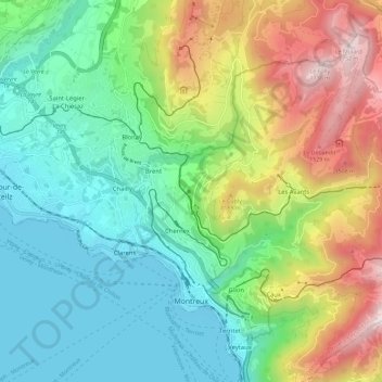
Name: Montreux topographic map, elevation, terrain.
Average elevation: 807 m
Minimum elevation: 365 m
Maximum elevation: 2,017 m
Make a donation
Gear up for your next adventure:
As an Amazon Associate, this site earns from qualifying purchases at no extra cost to you.
Other topographic maps
Click on a map to view its topography, its elevation and its terrain.
Les Avants
Switzerland > Vaud > District de la Riviera-Pays-d’Enhaut > Montreux
Average elevation: 1,111 m
Le Crêt
Switzerland > Vaud > District de la Riviera-Pays-d’Enhaut > Rougemont
Average elevation: 1,229 m
Le Mont-Pèlerin
Switzerland > Vaud > District de la Riviera-Pays-d’Enhaut > Chardonne > Le Mont-Pèlerin
Average elevation: 666 m
Pallens
Switzerland > Vaud > District de la Riviera-Pays-d’Enhaut > Montreux > Chernex
Average elevation: 596 m
Make a donation
Gear up for your next adventure:
As an Amazon Associate, this site earns from qualifying purchases at no extra cost to you.