
Town of Hillsdale topographic map
Interactive map
Click on the map to display elevation.
About this map
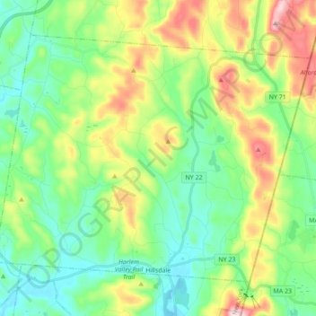
Name: Town of Hillsdale topographic map, elevation, terrain.
Location: Town of Hillsdale, Columbia County, New York, United States (42.17418 -73.61505 42.27389 -73.44298)
Average elevation: 306 m
Minimum elevation: 183 m
Maximum elevation: 573 m
Other topographic maps
Click on a map to view its topography, its elevation and its terrain.
New Lebanon Center
United States > New York > Columbia County > Town of New Lebanon
Average elevation: 284 m