
Make a donation
Gear up for your next adventure:
As an Amazon Associate, this site earns from qualifying purchases at no extra cost to you.
Al Sout topographic map
Click on the map to display elevation.
Make a donation
Gear up for your next adventure:
As an Amazon Associate, this site earns from qualifying purchases at no extra cost to you.
About this map
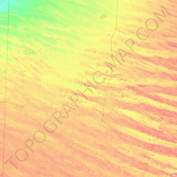
Name: Al Sout topographic map, elevation, terrain.
Location: Al Sout, Abu Dhabi, Abu Dhabi Emirate, United Arab Emirates (23.45198 54.40071 23.97844 55.04175)
Average elevation: 106 m
Minimum elevation: 43 m
Maximum elevation: 175 m
Make a donation
Gear up for your next adventure:
As an Amazon Associate, this site earns from qualifying purchases at no extra cost to you.
Other topographic maps
Click on a map to view its topography, its elevation and its terrain.
Al Fay Forest Park
United Arab Emirates > Abu Dhabi Emirate > Abu Dhabi > Abu Dhabi
Average elevation: 2 m
Make a donation
Gear up for your next adventure:
As an Amazon Associate, this site earns from qualifying purchases at no extra cost to you.
Make a donation
Gear up for your next adventure:
As an Amazon Associate, this site earns from qualifying purchases at no extra cost to you.
Abu Al Abyad
United Arab Emirates > Abu Dhabi Emirate > Abu Dhabi > Abu Al Abyad Island
Average elevation: 4 m