
Make a donation
Gear up for your next adventure:
As an Amazon Associate, this site earns from qualifying purchases at no extra cost to you.
Pichilemu topographic map
Click on the map to display elevation.
Make a donation
Gear up for your next adventure:
As an Amazon Associate, this site earns from qualifying purchases at no extra cost to you.
Pichilemu
Pichilemu is located 126 kilometres (78 mi) west of San Fernando, in the westernmost area of the O'Higgins Region, on the coast of the Pacific Ocean. It is within a three-hour drive of the Andes Mountains. It is near the Cordillera de la Costa (Coastal Mountain Range) which rises to 2,000 metres (6,562 ft) in elevation.
Make a donation
Gear up for your next adventure:
As an Amazon Associate, this site earns from qualifying purchases at no extra cost to you.
About this map
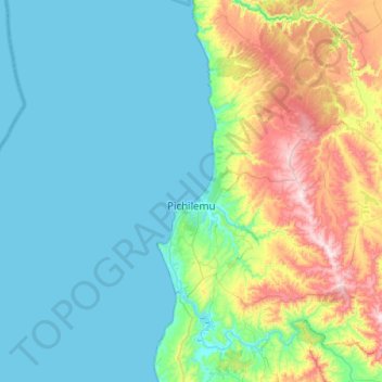
Name: Pichilemu topographic map, elevation, terrain.
Average elevation: 127 m
Minimum elevation: 0 m
Maximum elevation: 602 m
Make a donation
Gear up for your next adventure:
As an Amazon Associate, this site earns from qualifying purchases at no extra cost to you.
Other topographic maps
Click on a map to view its topography, its elevation and its terrain.
Marchigüe
Chile > O'Higgins Region > Provincia de Cardenal Caro > Marchigüe > Marchigüe
Average elevation: 150 m