Geolocate

Daverdisse topographic map

Interactive map

Click on the map to display elevation.

About this map

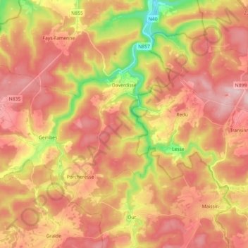
Name: Daverdisse topographic map, elevation, terrain.

Location: Daverdisse, Neufchâteau, Luxembourg, Wallonia, 6929, Belgium (49.96129 4.97302 50.04542 5.15206)

Average elevation: 362 m

Minimum elevation: 198 m

Maximum elevation: 472 m

Other topographic maps

Click on a map to view its topography, its elevation and its terrain.

Molinfaing

Belgium > Luxembourg > Neufchâteau

Average elevation: 469 m

Castle Amerois

Belgium > Luxembourg > Neufchâteau > Bouillon

Average elevation: 401 m

Rondu

Belgium > Luxembourg > Neufchâteau

Average elevation: 486 m

Laviot

Belgium > Luxembourg > Neufchâteau > Bouillon > Rochehaut

Average elevation: 297 m

Bouillon

Belgium > Luxembourg > Neufchâteau > Bouillon

Average elevation: 338 m

Frahan

Belgium > Luxembourg > Neufchâteau > Bouillon > Rochehaut

Average elevation: 291 m

Maisoncelle

Belgium > Luxembourg > Neufchâteau > Ebly > Maisoncelle

Average elevation: 474 m