Geolocate

Skopun topographic map

Interactive map

Click on the map to display elevation.

About this map

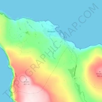
Name: Skopun topographic map, elevation, terrain.

Location: Skopun, Sandoy region, 240, Faroe Islands (61.87745 -6.95291 61.91419 -6.86575)

Average elevation: 120 m

Minimum elevation: -7 m

Maximum elevation: 410 m

Other topographic maps

Click on a map to view its topography, its elevation and its terrain.

Sandur

Faroe Islands > Sandoy region

Sandur can be reached from Tórshavn via the Sandoyartunnilin in circa 30 minutes. A direct Strandfaraskip Landsins bus service connects the two. All villages on the island except Skarvanes can be reached by bus from Sandur. They are therefore suitable for day trips. Due to the topography of the island…

Average elevation: 128 m

Skúvoy

Faroe Islands > Sandoy region > Skúvoy

Average elevation: 97 m