Geolocate

Wisła topographic map

Interactive map

Click on the map to display elevation.

About this map

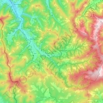
Name: Wisła topographic map, elevation, terrain.

Location: Wisła, Cieszyn County, Silesian Voivodeship, Poland (49.58533 18.80458 49.68626 19.01747)

Average elevation: 706 m

Minimum elevation: 367 m

Maximum elevation: 1,202 m

Other topographic maps

Click on a map to view its topography, its elevation and its terrain.

Ustroń

Poland > Silesian Voivodeship > Cieszyn County

Average elevation: 467 m

Istebna

Poland > Silesian Voivodeship > Cieszyn County

Average elevation: 662 m

Ustroń

Poland > Silesian Voivodeship > Cieszyn County > Ustroń

Average elevation: 486 m

Wisła

Poland > Silesian Voivodeship > Cieszyn County

Average elevation: 651 m

Jelenica

Poland > Silesian Voivodeship > Cieszyn County > Ustroń

Average elevation: 441 m