Geolocate

Leh topographic map

Interactive map

Click on the map to display elevation.

Leh

Leh (/ˈlɛ/) (Ladakhi: གླེ) is the joint capital and largest city of Ladakh, a union territory of India. Leh, located in the Leh district, was also the historical capital of the Kingdom of Ladakh, the seat of which was in the Leh Palace, the former residence of the royal family of Ladakh, built in the same style and about the same time as the Potala Palace in Tibet. Leh is at an altitude of 3,524 m (11,562 ft), and is connected via National Highway 1 to Srinagar in the southwest and to Manali in the south via the Leh-Manali Highway (part of National Highway 3 connect leh).

Wikipedia (CC-BY-SA 3.0)

About this map

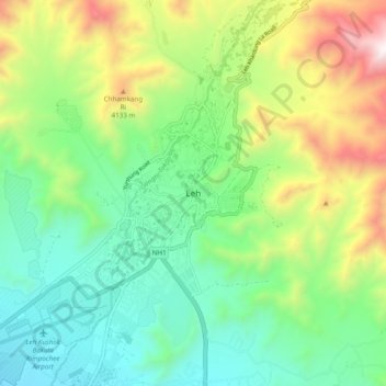
Name: Leh topographic map, elevation, terrain.

Location: Leh, Leh district, India (34.12420 77.54481 34.20420 77.62481)

Average elevation: 3,653 m

Minimum elevation: 3,206 m

Maximum elevation: 4,572 m

Other topographic maps

Click on a map to view its topography, its elevation and its terrain.

Bengaluru

India > Karnataka > Bangalore North

Bengaluru (formerly Bangalore) is situated in the southeastern part of Karnataka, India, within the Bengaluru Urban district. It lies at an elevation of approximately 900 meters (3,000 feet) above sea level, on the Deccan Plateau. This elevated position gives the city a moderate climate, with temperatures…

Average elevation: 886 m

Chennai

India > Tamil Nadu > Chennai

Chennai is located on the south–eastern coast of India in the north–eastern part of Tamil Nadu on a flat coastal plain known as the Eastern Coastal Plains. Its average elevation is around 6.7 metres (22 ft), and its highest point is 60 m (200 ft). Chennai is 2,184 kilometres (1,357 mi) south of Delhi,…

Average elevation: 8 m

Karnataka

India

The bulk of the state is in the Bayaluseeme region, the northern part of which is the second-largest arid region in India. The highest point in Karnataka is the Mullayanagiri hills in Chikmagalur district which has an altitude of 1,925 metres (6,316 ft). The two main river systems of the state are the Krishna…

Average elevation: 386 m

Mumbai

India > Maharashtra > Mumbai

Mumbai is on a narrow peninsula on the southwest of Salsette Island, which lies between the Arabian Sea to the west, Thane Creek to the east and Vasai Creek to the north. Mumbai's suburban district occupies most of the island. Navi Mumbai is east of Thane Creek and Thane is north of Vasai Creek. Mumbai…

Average elevation: 18 m

Kerala

India

Kerala was alternatively called Malabar in the foreign trade circles. Earlier, the term Malabar had also been used to denote Tulu Nadu and Kanyakumari which lie contiguous to Kerala on the southwestern coast of India, in addition to the modern state of Kerala. The people of Malabar were known as Malabars.…

Average elevation: 251 m

Himachal Pradesh

India

Due to extreme variation in elevation, great variation occurs in the climatic conditions of Himachal. The climate varies from hot and humid subtropical in the southern tracts to, with more elevation, cold, alpine, and glacial in the northern and eastern mountain ranges. The state's winter capital, Dharamsala…

Average elevation: 2,869 m

Rajasthan

India

The Aravalli Range runs across the state from the southwest peak Guru Shikhar (Mount Abu), which is 1,722 metres (5,650 ft) in height, to Khetri in the northeast. This range divides the state into 60% in the northwest of the range and 40% in the southeast. The northwest tract is sandy and unproductive with…

Average elevation: 254 m

Uttarakhand

India > Uttarakhand

Uttarakhand lies on the southern slope of the Himalaya range, and the climate and vegetation vary greatly with elevation, from glaciers at the highest elevations to subtropical forests at the lower elevations. The highest elevations are covered by ice and bare rock. Below them, between 3,000 and 5,000 metres…

Average elevation: 2,102 m

Hyderabad

India > Telangana > Bahadurpura mandal

Hyderabad (/ˈhaɪdərəbæd/ HY-dər-ə-bad; Telugu: [ˈɦaɪ̯daraːbaːd], Urdu: [ˈɦɛːdəɾaːbaːd]) is the capital and largest city of the Indian state of Telangana. It occupies 650 km2 (250 sq mi) on the Deccan Plateau along the banks of the Musi River, in the northern part of Southern India. With an…

Average elevation: 549 m

West Bengal

India

The distribution of vegetation in northern West Bengal is dictated by elevation and precipitation. For example, the foothills of the Himalayas, the Dooars, are densely wooded with sal and other tropical evergreen trees. Above an elevation of 1,000 metres (3,300 ft), the forest becomes predominantly…

Average elevation: 182 m

Thane

India > Maharashtra > Thane Taluka

Average elevation: 54 m

Dongargaon

India > Maharashtra > Akola > Dongargaon

Average elevation: 294 m

Delhi

India

The topography of the medieval fort Purana Qila on the banks of the river Yamuna matches the literary description of the citadel Indraprastha in the Sanskrit epic Mahabharata; however, excavations in the area have revealed no signs of an ancient built environment. From the early 13th century until the mid-19th…

Average elevation: 218 m

Bangalore Urban

India > Karnataka

Average elevation: 856 m

Maharashtra

India

Maharashtra with a total area of 307,713 km2 (118,809 sq mi), is the third-largest state by area in terms of land area and constitutes 9.36 per cent of India's total geographical area. The State lies between 15°35' N to 22°02' N latitude and 72°36' E to 80°54' E longitude. It occupies the western and…

Average elevation: 346 m

Telangana

India

Average elevation: 320 m

Tamil Nadu

India

The annual rainfall of the state is about 945 mm (37.2 in) of which 48 per cent is through the northeast monsoon, and 32 per cent through the southwest monsoon. Since the state is entirely dependent on rains for recharging its water resources, monsoon failures lead to acute water scarcity and severe drought.…

Average elevation: 253 m

Hyderabad

India > Telangana > Bahadurpura mandal

Hyderabad (/ˈhaɪdərəbæd/ HY-dər-ə-bad; Telugu: [ˈɦaɪ̯daraːbaːd], Urdu: [ˈɦɛːdəɾaːbaːd]) is the capital and largest city of the Indian state of Telangana. It occupies 650 km2 (250 sq mi) on the Deccan Plateau along the banks of the Musi River, in the northern part of Southern India. With an…

Average elevation: 549 m

Tamil Nadu

India

The annual rainfall of the state is about 945 mm (37.2 in) of which 48 per cent is through the northeast monsoon, and 32 per cent through the southwest monsoon. Since the state is entirely dependent on rains for recharging its water resources, monsoon failures lead to acute water scarcity and severe drought.…

Average elevation: 253 m

Kerala

India

Kerala was alternatively called Malabar in the foreign trade circles. Earlier, the term Malabar had also been used to denote Tulu Nadu and Kanyakumari which lie contiguous to Kerala on the southwestern coast of India, in addition to the modern state of Kerala. The people of Malabar were known as Malabars.…

Average elevation: 251 m

Andhra Pradesh

India

Andhra Pradesh topographical map

Average elevation: 269 m

Bommalaramaram mandal

India > Telangana

Average elevation: 522 m

Banoh

India > Madhya Pradesh > Pathardi Tahsil

Average elevation: 426 m

Ajnala

India > Punjab > Ajnala Tahsil

Average elevation: 229 m

Pune District

India > Maharashtra

Average elevation: 521 m

Punjab

India

Punjab is in northwestern India and has a total area of 50,362 square kilometres (19,445 sq mi). Punjab is bordered by Pakistan's Punjab province on the west, Jammu and Kashmir on the north, Himachal Pradesh on the northeast and Haryana and Rajasthan on the south. Most of Punjab lies in a fertile, alluvial…

Average elevation: 477 m

Odisha

India

Three-quarters of the state is covered in mountain ranges. Deep and broad valleys have been made in them by rivers. These valleys have fertile soil and are densely populated. Odisha also has plateaus and rolling uplands, which have lower elevation than the plateaus. The highest point in the state is Deomali at…

Average elevation: 228 m

Thane

India > Maharashtra > Thane Taluka

Average elevation: 54 m

Jammu and Kashmir

India

Jammu and Kashmir is home to several valleys such as the Kashmir Valley, Tawi Valley, Chenab Valley, Poonch Valley, Sind Valley, and Lidder Valley. The Kashmir valley is 100 km (62 mi) wide and 15,520.3 km2 (5,992.4 sq mi) in area. The Himalayas divide the Kashmir valley from the Tibetan plateau while the Pir…

Average elevation: 2,430 m

Uppunuthala mandal

India > Telangana

Average elevation: 442 m

Kalakada

India > Andhra Pradesh

Average elevation: 520 m

Navi Mumbai

India > Maharashtra > Thane Taluka

Navi Mumbai (Marathi pronunciation: [nəʋiː mumbəiː]), is a planned city situated on the west coast of the Indian subcontinent, located in the Konkan division of Maharashtra state, on the mainland of India. Navi Mumbai is part of the Mumbai Metropolitan Region (MMR). The city is divided into two, North…

Average elevation: 22 m

Musi River

India > Telangana > Hyderabad

Average elevation: 490 m

Mumbai

India > Maharashtra

Average elevation: 25 m

Arunachal Pradesh

India

The climate of Arunachal Pradesh varies with elevation. The low-altitude areas have a humid subtropical climate. High-altitude areas (3500–5500 m) have a subtropical highland climate and alpine climate. Arunachal Pradesh receives 2,000 to 5,000 millimetres (79 to 197 in) of rainfall annually, 70%–80%…

Average elevation: 2,432 m

Tripura

India

The physiography is characterised by hill ranges, valleys and plains. The state has five anticlinal ranges of hills running north to south, from Boromura in the west, through Atharamura, Longtharai and Shakhan, to the Jampui Hills in the east. The intervening synclines are the Agartala–Udaipur,…

Average elevation: 85 m

Meghalaya

India

Meghalaya, alongside neighbouring Indian states, has been of archaeological interest. People have lived in Meghalaya since the Neolithic period. Neolithic sites discovered so far are located in areas of high elevation in Khasi Hills, Garo Hills and in neighbouring states, where Neolithic style jhum or shifting…

Average elevation: 244 m

Jharkhand

India

Average elevation: 277 m

Sikkim

India

Situated in the Himalayan mountains, the state of Sikkim is characterised by mountainous terrain. Almost the entire state is hilly, with an elevation ranging from 280 metres (920 ft) in the south at the border with West Bengal to 8,586 metres (28,169 ft) in northern peaks near Nepal and Tibet. The summit of…

Average elevation: 3,784 m

Jammu and Kashmir

India

Jammu and Kashmir is home to several valleys such as the Kashmir Valley, Tawi Valley, Chenab Valley, Poonch Valley, Sind Valley, and Lidder Valley. The Kashmir valley is 100 km (62 mi) wide and 15,520.3 km2 (5,992.4 sq mi) in area. The Himalayas divide the Kashmir valley from the Tibetan plateau while the Pir…

Average elevation: 2,430 m

Bengaluru

India > Karnataka > Bangalore North

Bengaluru (formerly Bangalore) is situated in the southeastern part of Karnataka, India, within the Bengaluru Urban district. It lies at an elevation of approximately 900 meters (3,000 feet) above sea level, on the Deccan Plateau. This elevated position gives the city a moderate climate, with temperatures…

Average elevation: 886 m

Gujarat

India

Average elevation: 138 m

Madhya Pradesh

India

Madhya Pradesh literally means "Central Province", and is located in the geographic heart of India in between the latitude of 21.6°N–26.30°N and longitude of 74°9'E–82°48'E. The state straddles the Narmada River, which runs east and west between the Vindhya and Satpura ranges; these ranges and the…

Average elevation: 347 m

Koderma

India > Jharkhand

Average elevation: 343 m

Agara Lake

India > Karnataka > Bangalore South

Average elevation: 885 m

Kachchh

India > Gujarat

Average elevation: 38 m

Bachupally mandal

India > Telangana

Average elevation: 593 m

Purulia

India > West Bengal

Several rivers flow across Purulia district. Among these Kangsabati, Kumari, Silabati(silai), Dwarakeswar, Subarnarekha and Damodar are the important ones. Although several rivers flows across the district, 50% of the water run off due to the undulated topography. There are also several Small dams like…

Average elevation: 225 m

Darjeeling

India > West Bengal

The Darjeeling hill area is formed of comparatively recent rock structure that has a direct bearing on landslides. Heavy monsoon precipitation contributes to the landslides. Soils of Darjeeling hill areas are extremely varied, depending on elevation, degree of slope, vegetative cover and geolithology.

Average elevation: 730 m

Kaikatty

India > Kerala > Chittur

Average elevation: 929 m

Manipur

India

The state lies at a latitude of 23°83'N – 25°68'N and a longitude of 93°03'E – 94°78'E. The total area covered by the state is 22,327 square kilometres (8,621 sq mi). The capital lies in an oval-shaped valley of approximately 700 square miles (2,000 km2), surrounded by blue mountains, at an elevation…

Average elevation: 810 m

Gurugram

India > Haryana

Average elevation: 230 m

Bihar

India

Bihar covers a total area of 94,163 km2 (36,357 sq mi), with an average elevation above sea level of 173 feet (53 m). It is land locked by Nepal in the north, Jharkhand in the south West Bengal in the east and Uttar Pradesh to the west. It has three parts on the basis of physical and structural conditions: the…

Average elevation: 605 m

Himachal Pradesh

India

Due to extreme variation in elevation, great variation occurs in the climatic conditions of Himachal Pradesh. The climate varies from hot and humid subtropical in the southern tracts to, with more elevation, cold, alpine, and glacial in the northern and eastern mountain ranges. The state's winter capital,…

Average elevation: 2,869 m

Madurai

India > Tamil Nadu > Madurai

Madurai is located at 9°56′N 78°07′E / 9.93°N 78.12°E / 9.93; 78.12. It has an average elevation of 101 metres. The city of Madurai lies on the flat and fertile plain of the river Vaigai, which runs in the northwest-southeast direction through the city, dividing it into two almost equal…

Average elevation: 138 m

Mizoram

India

Mizoram is a land of rolling hills, valleys, rivers and lakes. As many as 21 major hill ranges or peaks of different heights run through the length and breadth of the state, with plains scattered here and there. The average height of the hills to the west of the state is about 1,000 metres (3,300 ft). These…

Average elevation: 544 m

Goa

India > Goa

Average elevation: 227 m

Chhattisgarh

India

Average elevation: 389 m

Sector 90

India > Haryana > Gurgaon

Average elevation: 226 m

Ashoknagar

India > Madhya Pradesh

Ashoknagar is situated at the average elevation of 507 metres(1640 ft) above sea level. It is in the plateau region. It has an agricultural topography. The plateau is an extension of the Deccan Traps, formed between 60 and 68 million years ago at the end of the Cretaceous period. In this region, the main…

Average elevation: 447 m

Nedumangad

India > Kerala

Average elevation: 229 m

Pune

India > Maharashtra

Pune lies on the western margin of the Deccan plateau, at an altitude of 560 m (1,840 ft) above sea level. It is on the leeward side of the Sahyadri mountain range, which forms a barrier from the Arabian Sea. It is a hilly city, with Vetal Hill rising to 800 m (2,600 ft) above sea level. The Sinhagad fort is…

Average elevation: 616 m

Ladakh

India

The Kargil War of 1999, codenamed "Operation Vijay" by the Indian Army, saw infiltration by Pakistani troops into parts of Western Ladakh, namely Kargil, Dras, Mushkoh, Batalik and Chorbatla, overlooking key locations on the Srinagar-Leh highway. Extensive operations were launched in high altitudes by the…

Average elevation: 4,726 m

Haryana

India

Haryana is a landlocked state in northern India. It is between 27°39' to 30°35' N latitude and between 74°28' and 77°36' E longitude. The total geographical area of the state is 4.42 m ha, which is 1.4% of the geographical area of the country. The altitude of Haryana varies between 700 and 3600 ft (200…

Average elevation: 281 m

Uttar Pradesh

India

Uttar Pradesh, with a total area of 243,290 square kilometres (93,935 sq mi), is India's fourth-largest state in terms of land area and is roughly of same size as United Kingdom. It is situated on the northern spout of India and shares an international boundary with Nepal. The Himalayas border the state on the…

Average elevation: 954 m

Rajasthan

India

The Aravalli Range runs across the state from the southwest peak Guru Shikhar (Mount Abu), which is 1,722 metres (5,650 ft) in height, to Khetri in the northeast. This range divides the state into 60% in the northwest of the range and 40% in the southeast. The northwest tract is sandy and unproductive with…

Average elevation: 254 m

Vijayapur

India > Madhya Pradesh > Pichhore Tahsil

Average elevation: 387 m

Ganjam

India > Odisha

Average elevation: 248 m

Una Taluka

India > Gujarat

Average elevation: 37 m

Patan

India > Maharashtra > Mawal

Average elevation: 689 m

Kalindi Khal Area

India > Uttarakhand > Bhatwari

Average elevation: 5,857 m

Sector 57

India > Haryana > Gurgaon

Average elevation: 235 m

Bommasandra

India > Karnataka > Anekal

Average elevation: 900 m

Andhra Pradesh

India

Andhra Pradesh topographical map

Average elevation: 269 m

New Delhi

India > Delhi

Average elevation: 230 m

Brijpur

India > Madhya Pradesh > Panna Tahsil

Average elevation: 359 m

Teesta River

India

Through its course, the Teesta river has carved out ravines and gorges in Sikkim meandering through the hills with the hill station of Kalimpong lying just off the river and the city of Siliguri at the foothills of Himalaya. Variegated vegetation can be seen along this route. At lower elevations, tropical…

Average elevation: 1,496 m

Ground

India > Karnataka > Bangalore South

Average elevation: 889 m

Patparganj

India > Delhi > Mayur Vihar Tehsil

Average elevation: 205 m

Goa

India

Goa is a part of the coastal country known as the Konkan, which is an escarpment rising up to the Western Ghats range of mountains, which separate it from the Deccan Plateau. The highest point is the Sonsogor Peak, with an altitude of 1,026 m (3,366 ft). Goa has a coastline of 160 km (99 mi).

Average elevation: 228 m

Coimbatore District

India > Tamil Nadu

Apart from the species common to the plains, wild elephants, wild boars leopards, tigers, bison, species of deer, Nilgiri tahr, sloth bear and black-headed oriole can be found. The Anamalai Wildlife Sanctuary 88 km (55 mi) in the Western Ghats at an altitude of 1,400 meters covers an area of 958 km2. More than…

Average elevation: 551 m

Ooty Lake

India > Tamil Nadu > Udhagamandalam > Udhagamandalam

Average elevation: 2,235 m

Yerragondapalem

India > Andhra Pradesh

Average elevation: 197 m

Balh

India > Himachal Pradesh > Dharamshala > Dharamshala

Average elevation: 1,906 m

Kharkhoda

India > Haryana

Average elevation: 222 m

Aalo HQ

India > Arunachal Pradesh

Average elevation: 750 m

Kada Agrahara

India > Karnataka > Anekal

Average elevation: 895 m

Malappuram

India > Kerala

Bounded by Kozhikode district to the northwest, Wayanad district to the northeast, Nilgiri hills to the east, Palakkad district to the southeast, Thrissur district to the southwest, and Arabian Sea to the west, Malappuram has a total geographical area of 3,554 km2, which ranks third in the state in terms of…

Average elevation: 224 m

Hamirpur

India > Himachal Pradesh

Hamirpur district is situated between 31°25′N and 31°52′N and between 76°18′E and 76°44′E. Hamirpur (town), the district headquarters, is situated at an altitude of 780 m with the highest point being the Awah Devi peak at an altitude of 1250 m.

Average elevation: 759 m

Adam's Bridge

India > Tamil Nadu > Rameswaram

Average elevation: 0 m

Uttar Pradesh

India

Uttar Pradesh, with a total area of 243,290 square kilometres (93,935 sq mi), is India's fourth-largest state in terms of land area and is roughly of same size as United Kingdom. It is situated on the northern spout of India and shares an international boundary with Nepal. The Himalayas border the state on the…

Average elevation: 954 m

Andaman and Nicobar Islands

India

The islands have a 1,962 km (1,219 mi) long coast-line. The topography of the territory varies significantly across various islands. The islands may have sandy, rocky sandstone or marshy beaches on the coastlines and might be surrounded by shoals and coral reefs. The altitude varies significantly from…

Average elevation: 1 m

Jodhpur

India > Rajasthan > Jodhpur Tehsil

Average elevation: 238 m

Telangana

India

Average elevation: 320 m

Wayanad

India > Kerala

Wayanad (Malayalam: [ʋɐjɐnaːɖɨ̆]) is a district in the north-east of the Indian state of Kerala, with its administrative headquarters at the municipality of Kalpetta. It is the only plateau in Kerala. The Wayanad Plateau forms a continuation of the Mysore Plateau, the southern portion of the Deccan…

Average elevation: 724 m

Pallikaranai Marsh

India > Tamil Nadu > Chennai

Average elevation: 2 m