Geolocate

Capel topographic map

Click on the map to display elevation.

About this map

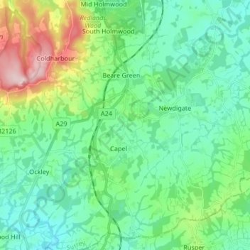
Name: Capel topographic map, elevation, terrain.

Location: Capel, Mole Valley, Surrey, England, United Kingdom (51.11991 -0.37124 51.20366 -0.28656)

Average elevation: 102 m

Minimum elevation: 40 m

Maximum elevation: 291 m

Surrey trails, hiking, mountain biking, running and outdoor activities

Other topographic maps

Click on a map to view its topography, its elevation and its terrain.

Clark's Green

United Kingdom > England > Surrey > Mole Valley > Capel

Average elevation: 85 m

Gear up for your next adventure:

🎒Hiking Child Carriers - Explore the outdoors with the whole family safely
🔋Rechargeable Batteries - Eco-friendly power for headlamps and older GPS units
📱Phone Mounts for Hiking - Secure mounts to carry your phone on trails
🧊Insulated Flasks - Keeps drinks hot or cold during hikes
🧰First Aid Kits - Essential safety kits for outdoor activities

As an Amazon Associate, this site earns from qualifying purchases at no extra cost to you.