Geolocate

Culpeper topographic map

Click on the map to display elevation.

About this map

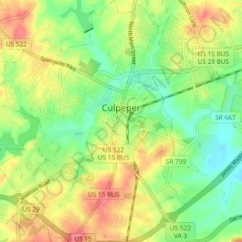
Name: Culpeper topographic map, elevation, terrain.

Location: Culpeper, Culpeper County, Virginia, 22701, United States (38.44113 -78.03194 38.49575 -77.95625)

Average elevation: 131 m

Minimum elevation: 95 m

Maximum elevation: 231 m

Other topographic maps

Click on a map to view its topography, its elevation and its terrain.

Rapidan

United States > Virginia > Culpeper County

Average elevation: 105 m

Rapidan

United States > Virginia > Culpeper County

Average elevation: 105 m

Rixeyville

United States > Virginia > Culpeper County

Average elevation: 119 m

Gear up for your next adventure:

🥾Walking Shoes - Lightweight walking shoes for countryside and coastal paths
👟Women's Trail Running Shoes - Agile footwear for fell running and technical trails
🎒Hiking Backpacks - Comfortable backpacks for day hikes and multi-day treks
🧴Sport Sunscreen Sticks - High-protection sunblock that won't run into your eyes on the trail
🌦️Portable Weather Meters - Handheld tools for monitoring weather conditions

As an Amazon Associate, this site earns from qualifying purchases at no extra cost to you.