Geolocate

Dumas topographic map

Click on the map to display elevation.

About this map

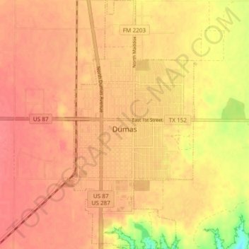
Name: Dumas topographic map, elevation, terrain.

Location: Dumas, Moore County, Texas, 79029, United States (35.83398 -101.98197 35.89426 -101.94548)

Average elevation: 1,112 m

Minimum elevation: 1,069 m

Maximum elevation: 1,127 m

Other topographic maps

Click on a map to view its topography, its elevation and its terrain.

Sheerin Junction

United States > Texas > Moore County

Average elevation: 1,077 m

Gear up for your next adventure:

🌄Outdoor Binoculars - Compact binoculars for landscape observation
🥼Base Layers - Thermal base layers for temperature regulation
🧦Merino Wool Hiking Socks - Moisture-wicking socks to prevent blisters during long mountain walks
🚶Walking Pedometers - Simple distance tracking for casual trail walkers
🧥Breathable Waterproof Jackets - Essential rain protection for the unpredictable British climate

As an Amazon Associate, this site earns from qualifying purchases at no extra cost to you.