
Santiago Tianguistenco topographic map
Interactive map
Click on the map to display elevation.
Santiago Tianguistenco
The municipality lies in the Trans-Mexican Volcanic Belt in the sub-province of the Lakes and Volcanoes of Anahuac. 35% of the municipality is mountainous, 30% is arable and the rest is developed. The topography of the municipality varies due to its size. The eastern portions are highest as they are in the Ajusco mountains with an average altitude of over 3,600 meters above sea level. The rest of the municipal is part of the Lerma River plain, which close to level, sloping slightly at around 2,600 meters. Within the municipality there are a number of small volcanoes such as Los Cuates, Santiago Tilapa, Las Ratas, Teconto and others that break up the plains area. The main surface water is the Lerma River, which crosses the municipality from north to south, although there are a large number of small intermittent streams, and the smaller Jalatlaco River. Along this river are waterworks constructed in the 1940s to supply water to Mexico City. There also a number of wells here with the same purpose. The climate here is fairly cold (C(E) (m) (w)) with freezing temperatures expected around 100 days per year between October and May. Wild vegetation varies depending on the altitude. The mountain regions have forests of oak, pine and fir, with the lower levels having scrub and grasslands. Most fauna here is small and medium-sized mammals such as coyotes, skunks, rabbits and squirrels with reptiles such as rattlesnakes and birds such as crows, ducks and quail. The area used to have deer, buzzards and wildcats, but these have disappeared.
About this map
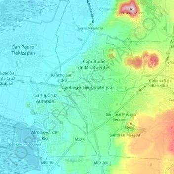
Name: Santiago Tianguistenco topographic map, elevation, terrain.
Average elevation: 2,645 m
Minimum elevation: 2,561 m
Maximum elevation: 2,940 m