
Fushan District topographic map
Interactive map
Click on the map to display elevation.
About this map
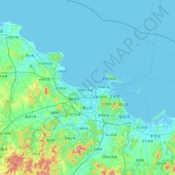
Name: Fushan District topographic map, elevation, terrain.
Location: Fushan District, Yantai City, Shandong, 265500, China (37.23354 120.83802 37.76040 121.36427)
Average elevation: 69 m
Minimum elevation: -3 m
Maximum elevation: 641 m
Other topographic maps
Click on a map to view its topography, its elevation and its terrain.
Menlou
China > Shandong > Fushan District
Menlou, Fushan District, Yantai, Shandong, 265500, China
Average elevation: 75 m