
Fort-Liberté topographic map
Interactive map
Click on the map to display elevation.
About this map
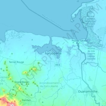
Name: Fort-Liberté topographic map, elevation, terrain.
Average elevation: 38 m
Minimum elevation: -1 m
Maximum elevation: 1,036 m
The fort is 40 nautical miles (74 km) from Port-de-Paix (the capital of Nord-Ouest) and 290 kilometres (180 mi) from Port-au-Prince (the capital of Haiti). The average elevation of the town is about 1 metre (3.3 ft).