
Santa Lucrécia de Algeriz e Navarra topographic map
Interactive map
Click on the map to display elevation.
About this map
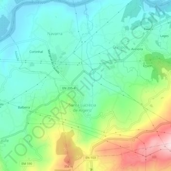
Name: Santa Lucrécia de Algeriz e Navarra topographic map, elevation, terrain.
Location: Santa Lucrécia de Algeriz e Navarra, Braga, Portugal (41.57898 -8.39280 41.61435 -8.34731)
Average elevation: 149 m
Minimum elevation: 23 m
Maximum elevation: 451 m
Other topographic maps
Click on a map to view its topography, its elevation and its terrain.
Braga
The topography in the municipality is characterized by irregular valleys, interspersed by mountainous spaces, fed by rivers running in parallel with the principal rivers. In the north it is limited by the Cávado River, in the south by terrain of the Serra dos Picos to a height of 566 metres (1,857 ft) and…
Average elevation: 204 m