
Lüneburg topographic map
Interactive map
Click on the map to display elevation.
About this map
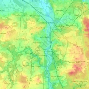
Name: Lüneburg topographic map, elevation, terrain.
Location: Lüneburg, Lower Saxony, Germany (53.19168 10.33083 53.28664 10.51436)
Average elevation: 35 m
Minimum elevation: 5 m
Maximum elevation: 82 m
Other topographic maps
Click on a map to view its topography, its elevation and its terrain.
Horburg
Germany > Lower Saxony > Lüneburg
Horburg, Barum, Samtgemeinde Bardowick, Lüneburg, Lower Saxony, 21395, Germany
Average elevation: 5 m
Rassau
Germany > Lower Saxony > Lüneburg > Amt Neuhaus
Rassau, Amt Neuhaus, Lüneburg, Lower Saxony, 29456, Germany
Average elevation: 17 m