
Make a donation
Gear up for your next adventure:
As an Amazon Associate, this site earns from qualifying purchases at no extra cost to you.
Sawla topographic map
Click on the map to display elevation.
Make a donation
Gear up for your next adventure:
As an Amazon Associate, this site earns from qualifying purchases at no extra cost to you.
Sawla
Sawla (also known as Felege Neway) is a town in southern Ethiopia. Located in Gofa Zone of the Southern Nations, Nationalities and Peoples' Region, this town has a latitude and longitude of 6°18′N 36°53′E / 6.300°N 36.883°E / 6.300; 36.883 with an elevation of 1,395 metres (4,577 ft) above sea level. It is surrounded by Demba Gofa woreda.
Make a donation
Gear up for your next adventure:
As an Amazon Associate, this site earns from qualifying purchases at no extra cost to you.
About this map
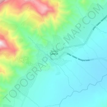
Name: Sawla topographic map, elevation, terrain.
Location: Sawla, Gamo Gofa, South Ethiopia Regional State, Ethiopia (6.26000 36.84333 6.34000 36.92333)
Average elevation: 1,485 m
Minimum elevation: 1,192 m
Maximum elevation: 2,538 m
Make a donation
Gear up for your next adventure:
As an Amazon Associate, this site earns from qualifying purchases at no extra cost to you.