
Make a donation
Gear up for your next adventure:
As an Amazon Associate, this site earns from qualifying purchases at no extra cost to you.
Sunshine Valley topographic map
Click on the map to display elevation.
Make a donation
Gear up for your next adventure:
As an Amazon Associate, this site earns from qualifying purchases at no extra cost to you.
About this map
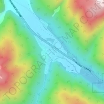
Name: Sunshine Valley topographic map, elevation, terrain.
Average elevation: 1,030 m
Minimum elevation: 657 m
Maximum elevation: 1,921 m
Make a donation
Gear up for your next adventure:
As an Amazon Associate, this site earns from qualifying purchases at no extra cost to you.
Other topographic maps
Click on a map to view its topography, its elevation and its terrain.
Falls Lake
Canada > British Columbia > Fraser Valley Regional District > Area B (South Fraser Canyon/Sunshine Valley)
Average elevation: 1,512 m
Hope Slide
Canada > British Columbia > Fraser Valley Regional District > Area B (South Fraser Canyon/Sunshine Valley)
Average elevation: 1,160 m
Serpentine Lake
Canada > British Columbia > Fraser Valley Regional District > Area B (South Fraser Canyon/Sunshine Valley)
Average elevation: 960 m