Geolocate

Atchison topographic map

Click on the map to display elevation.

About this map

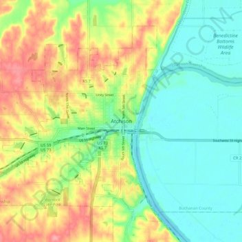
Name: Atchison topographic map, elevation, terrain.

Location: Atchison, Atchison County, Kansas, 66002, United States (39.52324 -95.15995 39.60324 -95.07995)

Average elevation: 271 m

Minimum elevation: 234 m

Maximum elevation: 328 m

Gear up for your next adventure:

🔪Outdoor Multi-Tools - Versatile tools for gear repairs and food prep in the wild
🧰Survival Kits - Emergency tools for remote environments
🧗Locking Carabiners - Secure gear to your pack or for light technical use
🥼Base Layers - Thermal base layers for temperature regulation
🛌Sleeping Bags - Warm and packable sleeping bags for outdoor nights

As an Amazon Associate, this site earns from qualifying purchases at no extra cost to you.