
Make a donation
Gear up for your next adventure:
As an Amazon Associate, this site earns from qualifying purchases at no extra cost to you.
Tzum topographic map
Click on the map to display elevation.
Make a donation
Gear up for your next adventure:
As an Amazon Associate, this site earns from qualifying purchases at no extra cost to you.
Tzum
Volgens een bekende sage hebben de bewoners van Oldeboorn gewedijverd met Tzum om de kerk met de hoogste toren. De Oldeboorners wilden de hoogste toren van Friesland hebben, wat betekende dat hun toren van de Doelhofkerk hoger moest worden dan die van Tzum. Daarom reisden twee mannen naar Tzum om te bepalen hoe hoog die toren precies was. Ze beklommen de toren en maten de hoogte met een touw. Daarna bleven ze in de plaatselijke herberg overnachten. Terwijl ze sliepen sneed de waardin een flink stuk van het touw af. Het uiteindelijke gevolg was dat de toren van Oldeboorn toch lager werd dan de toren van Tzum. De inwoners van Oldeboorn worden sindsdien tuorkemjitters (torenmeters) genoemd en die van Tzum lyntsjesnijers (lijntjesnijders).
Make a donation
Gear up for your next adventure:
As an Amazon Associate, this site earns from qualifying purchases at no extra cost to you.
About this map
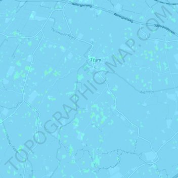
Name: Tzum topographic map, elevation, terrain.
Location: Tzum, Waadhoeke, Fryslân, Nederland (53.12952 5.52550 53.17215 5.60473)
Average elevation: 0 m
Minimum elevation: -3 m
Maximum elevation: 2 m
Make a donation
Gear up for your next adventure:
As an Amazon Associate, this site earns from qualifying purchases at no extra cost to you.
Other topographic maps
Click on a map to view its topography, its elevation and its terrain.
Make a donation
Gear up for your next adventure:
As an Amazon Associate, this site earns from qualifying purchases at no extra cost to you.
Make a donation
Gear up for your next adventure:
As an Amazon Associate, this site earns from qualifying purchases at no extra cost to you.
Make a donation
Gear up for your next adventure:
As an Amazon Associate, this site earns from qualifying purchases at no extra cost to you.
Laaxum
In 1718 stonden er acht huizen in de buurtschap en in 1851 zes. Aan het begin van de twintigste eeuw was Laaxum een plaats met zestien huizen en twee boerderijen, waarin samen meer dan honderd mensen woonden. In het begin van de eenentwintigste stonden er elf huizen en één boerderij. De haven werd ook wel…
Average elevation: 0 m
Make a donation
Gear up for your next adventure:
As an Amazon Associate, this site earns from qualifying purchases at no extra cost to you.
Make a donation
Gear up for your next adventure:
As an Amazon Associate, this site earns from qualifying purchases at no extra cost to you.
Make a donation
Gear up for your next adventure:
As an Amazon Associate, this site earns from qualifying purchases at no extra cost to you.
Make a donation
Gear up for your next adventure:
As an Amazon Associate, this site earns from qualifying purchases at no extra cost to you.
Skilleard
Schillaard werd in 1445 vermeld als Scallaert, in 1478 als Schillaerdt, in 1482 als Schellart en in 16e en 17e eeuw als Schillaerd. De plaatsnaam zou mogelijk verwijzen naar een terp (werth) bij een schelpenbank (skil-schelp). Een andere mogelijke betekenis is dat de terp/wierde scheef weglopend was, waarbij…
Average elevation: 0 m
Make a donation
Gear up for your next adventure:
As an Amazon Associate, this site earns from qualifying purchases at no extra cost to you.
Make a donation
Gear up for your next adventure:
As an Amazon Associate, this site earns from qualifying purchases at no extra cost to you.