
Make a donation
Gear up for your next adventure:
As an Amazon Associate, this site earns from qualifying purchases at no extra cost to you.
San Carlos topographic map
Click on the map to display elevation.
Make a donation
Gear up for your next adventure:
As an Amazon Associate, this site earns from qualifying purchases at no extra cost to you.
About this map
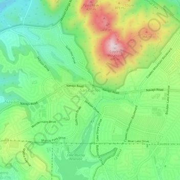
Name: San Carlos topographic map, elevation, terrain.
Average elevation: 207 m
Minimum elevation: 51 m
Maximum elevation: 472 m
Make a donation
Gear up for your next adventure:
As an Amazon Associate, this site earns from qualifying purchases at no extra cost to you.
Other topographic maps
Click on a map to view its topography, its elevation and its terrain.
Lake Murray Reservoir
United States > California > San Diego County > San Diego > San Carlos
Average elevation: 178 m
Los Peñasquitos Canyon Preserve
United States > California > San Diego County > San Diego > Sorrento Valley
Average elevation: 95 m
Make a donation
Gear up for your next adventure:
As an Amazon Associate, this site earns from qualifying purchases at no extra cost to you.
Cabrillo National Monument
United States > California > San Diego County > San Diego
The Old Point Loma Lighthouse is the highest point in the park and has been a San Diego icon since 1855. The lighthouse was closed in 1891, and the New Point Loma Lighthouse opened at a lower elevation, as fog and low clouds often obscured the light at its location 129 meters (422 feet) above sea level. The…
Average elevation: 13 m
Make a donation
Gear up for your next adventure:
As an Amazon Associate, this site earns from qualifying purchases at no extra cost to you.
Mission Trails Regional Park
United States > California > San Diego County > San Diego > San Carlos
Average elevation: 178 m
Torrey Pines State Natural Reserve
United States > California > San Diego County > San Diego
Average elevation: 37 m
Make a donation
Gear up for your next adventure:
As an Amazon Associate, this site earns from qualifying purchases at no extra cost to you.