
Make a donation
Gear up for your next adventure:
As an Amazon Associate, this site earns from qualifying purchases at no extra cost to you.
Spy topographic map
Click on the map to display elevation.
Make a donation
Gear up for your next adventure:
As an Amazon Associate, this site earns from qualifying purchases at no extra cost to you.
About this map
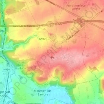
Name: Spy topographic map, elevation, terrain.
Location: Spy, Jemeppe-sur-Sambre, Namur, Wallonie, Belgique (50.46132 4.66703 50.50524 4.73299)
Average elevation: 143 m
Minimum elevation: 84 m
Maximum elevation: 195 m
Make a donation
Gear up for your next adventure:
As an Amazon Associate, this site earns from qualifying purchases at no extra cost to you.
Other topographic maps
Click on a map to view its topography, its elevation and its terrain.
Spy
Belgique > Namur > Namur > Jemeppe-sur-Sambre
La présence de l'Orneau explique la différence importante entre l'altitude la plus basse (85 m) en vallée et l'altitude la plus haute (195 m) sur le plateau.
Average elevation: 146 m