
Make a donation
Gear up for your next adventure:
As an Amazon Associate, this site earns from qualifying purchases at no extra cost to you.
Kupang topographic map
Click on the map to display elevation.
Make a donation
Gear up for your next adventure:
As an Amazon Associate, this site earns from qualifying purchases at no extra cost to you.
Kupang
Kupang is located in the southwestern tip of the island of Timor. It is solely bordered by the Kupang Regency on land, and on its northern shore by the Savu Sea. It has a land area of 180.27 square kilometers (which is divided into six administrative districts), along with a water area of 94.79 square kilometers. The area around the city is geologically inactive, with soil composition characterised by non-volcanic materials such as Latosol and Terra rossa. At its highest point, the city is 62 metres above sea level, with inclination varying from 0 - 5%. The topography of the city is mostly low-lying, but also includes groups of hills in the south and southwest, which has the effect of creating a relatively fertile catchment area.
Make a donation
Gear up for your next adventure:
As an Amazon Associate, this site earns from qualifying purchases at no extra cost to you.
About this map
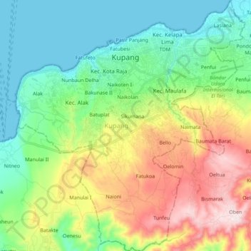
Name: Kupang topographic map, elevation, terrain.
Average elevation: 168 m
Minimum elevation: 0 m
Maximum elevation: 503 m
Make a donation
Gear up for your next adventure:
As an Amazon Associate, this site earns from qualifying purchases at no extra cost to you.
Other topographic maps
Click on a map to view its topography, its elevation and its terrain.
Make a donation
Gear up for your next adventure:
As an Amazon Associate, this site earns from qualifying purchases at no extra cost to you.
Make a donation
Gear up for your next adventure:
As an Amazon Associate, this site earns from qualifying purchases at no extra cost to you.
Make a donation
Gear up for your next adventure:
As an Amazon Associate, this site earns from qualifying purchases at no extra cost to you.
Make a donation
Gear up for your next adventure:
As an Amazon Associate, this site earns from qualifying purchases at no extra cost to you.
Gili Lawa Darat Island
Indonesia > East Nusa Tenggara > Manggarai Barat > Komodo
Average elevation: 13 m
Make a donation
Gear up for your next adventure:
As an Amazon Associate, this site earns from qualifying purchases at no extra cost to you.
Make a donation
Gear up for your next adventure:
As an Amazon Associate, this site earns from qualifying purchases at no extra cost to you.
Make a donation
Gear up for your next adventure:
As an Amazon Associate, this site earns from qualifying purchases at no extra cost to you.
View over the lake (behind wall)
Indonesia > East Nusa Tenggara > Manggarai Timur > Ranaka
Average elevation: 1,365 m
Pantai Ratenggaro (Beach)
Indonesia > East Nusa Tenggara > Sumba Barat Daya > Bondokodi
Average elevation: 12 m
Make a donation
Gear up for your next adventure:
As an Amazon Associate, this site earns from qualifying purchases at no extra cost to you.
Make a donation
Gear up for your next adventure:
As an Amazon Associate, this site earns from qualifying purchases at no extra cost to you.
Make a donation
Gear up for your next adventure:
As an Amazon Associate, this site earns from qualifying purchases at no extra cost to you.
Pasunga Cultural Village
Indonesia > East Nusa Tenggara > Sumba Tengah > Pasunga Cultural Village
Average elevation: 450 m
Make a donation
Gear up for your next adventure:
As an Amazon Associate, this site earns from qualifying purchases at no extra cost to you.