
Thank you for supporting this site ❤️
Make a donation
Make a donation
Gear up for your next adventure:
As an Amazon Associate, this site earns from qualifying purchases at no extra cost to you.
Val Vigezzo topographic map
Click on the map to display elevation.
Thank you for supporting this site ❤️
Make a donation
Make a donation
Gear up for your next adventure:
As an Amazon Associate, this site earns from qualifying purchases at no extra cost to you.
Val Vigezzo
Il territorio presenta una ricca vegetazione ed abbondanza di acque, nonostante la modesta altitudine delle montagne circostanti e quindi l'assenza di ghiacciai o nevai.
Thank you for supporting this site ❤️
Make a donation
Make a donation
Gear up for your next adventure:
As an Amazon Associate, this site earns from qualifying purchases at no extra cost to you.
About this map
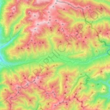
Name: Val Vigezzo topographic map, elevation, terrain.
Average elevation: 1,336 m
Minimum elevation: 252 m
Maximum elevation: 2,515 m
Thank you for supporting this site ❤️
Make a donation
Make a donation
Gear up for your next adventure:
As an Amazon Associate, this site earns from qualifying purchases at no extra cost to you.