
Make a donation
Gear up for your next adventure:
As an Amazon Associate, this site earns from qualifying purchases at no extra cost to you.
Gaza topographic map
Click on the map to display elevation.
Make a donation
Gear up for your next adventure:
As an Amazon Associate, this site earns from qualifying purchases at no extra cost to you.
Gaza
Central Gaza is situated on a low-lying and round hill with an elevation of 14 metres (46 ft) above sea level. Much of the modern city is built along the plain below the hill, especially to the north and east, forming Gaza's suburbs. The beach and the port of Gaza are located 3 kilometres (1.9 mi) west of the city's nucleus and the space in between is entirely built up on low-lying hills.
Make a donation
Gear up for your next adventure:
As an Amazon Associate, this site earns from qualifying purchases at no extra cost to you.
About this map
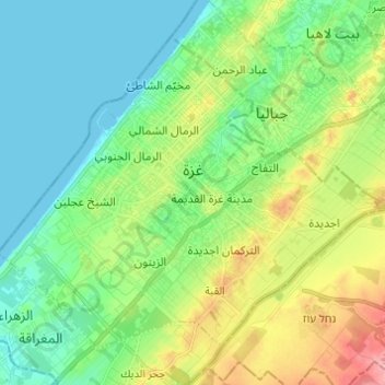
Name: Gaza topographic map, elevation, terrain.
Location: Gaza, Gaza Governorate, Gaza Strip, Palestinian Territory (31.46450 34.39615 31.54872 34.51814)
Average elevation: 36 m
Minimum elevation: 0 m
Maximum elevation: 118 m
Make a donation
Gear up for your next adventure:
As an Amazon Associate, this site earns from qualifying purchases at no extra cost to you.
Other topographic maps
Click on a map to view its topography, its elevation and its terrain.
Make a donation
Gear up for your next adventure:
As an Amazon Associate, this site earns from qualifying purchases at no extra cost to you.
Nablus
Palestinian Territories > Area A
Insofar as the hilly topography of the site would allow, the city was built on a Roman grid plan and settled with veterans who fought in the victorious legions and other foreign colonists. In the 2nd century CE, Emperor Hadrian built a grand theater in Neapolis that could seat up to 7,000 people. Coins found…
Average elevation: 645 m
Fatsael
Palestinian Territories > Judea and Samaria > Area C > Arvot Hayarden Regional Council
Average elevation: -220 m
Make a donation
Gear up for your next adventure:
As an Amazon Associate, this site earns from qualifying purchases at no extra cost to you.
Mount of Temptation
Palestinian Territories > Area A
The city of Jericho lies at the feet east of Mount Quruntul, at 258 m (846 ft) below sea level, with the nearby Jordan River and the Dead Sea at even lower elevations, further to the east and southeast. The mount has around 400 m (1,300 ft) of prominence over Jericho, which translates to an elevation of 138 m…
Average elevation: -49 m
Homesh
Palestinian Territories > Judea and Samaria > Area C > Shomron Regional Council
Average elevation: 452 m
Make a donation
Gear up for your next adventure:
As an Amazon Associate, this site earns from qualifying purchases at no extra cost to you.
Nofim
Palestinian Territories > Judea and Samaria > Area C > Shomron Regional Council
Average elevation: 319 m
Beit HaArava
Palestinian Territories > Judea and Samaria > Area C > Megilot Yam HaMelakh Regional Council
Average elevation: -294 m
Make a donation
Gear up for your next adventure:
As an Amazon Associate, this site earns from qualifying purchases at no extra cost to you.
Argaman
Palestinian Territories > Judea and Samaria > Area C > Arvot Hayarden Regional Council
Average elevation: -203 m
Make a donation
Gear up for your next adventure:
As an Amazon Associate, this site earns from qualifying purchases at no extra cost to you.
Make a donation
Gear up for your next adventure:
As an Amazon Associate, this site earns from qualifying purchases at no extra cost to you.
Mehora
Palestinian Territories > Judea and Samaria > Area C > Arvot Hayarden Regional Council
Average elevation: 200 m
Hamra
Palestinian Territories > Judea and Samaria > Area C > Arvot Hayarden Regional Council
Average elevation: -57 m
Make a donation
Gear up for your next adventure:
As an Amazon Associate, this site earns from qualifying purchases at no extra cost to you.
Bethlehem
Palestinian Territories > Area A > Bethlehem
Bethlehem is located at an elevation of about 775 meters (2,543 ft) above sea level, 30 meters (98 ft) higher than nearby Jerusalem. Bethlehem is situated on the Judean Mountains.
Average elevation: 553 m
Ro'i
Palestinian Territories > Judea and Samaria > Area C > Arvot Hayarden Regional Council
Average elevation: 46 m
Make a donation
Gear up for your next adventure:
As an Amazon Associate, this site earns from qualifying purchases at no extra cost to you.
Sanur
Palestinian Territories > Area A
Sanur is located in the highlands of the northern West Bank. The village is situated on an isolated hilltop along the western edge of the valley and seasonal lake of Marj Sanur, which is named after the village. To the west, Sanur is connected to the Hawarah Ridge of the Zawiya Highlands through a low-lying…
Average elevation: 423 m
Jenin
Palestinian Territories > Area A
Jenin is situated at the foot of the rugged northernmost hills (Jabal Nablus) of the West Bank, and along the southern edge of the Jezreel Valley (Marj Ibn Amer),[65] which the city overlooks.[66] Its highest elevation is about 250 meters above sea level and its lowest areas are 90 meters above sea level.[67]…
Average elevation: 194 m
Make a donation
Gear up for your next adventure:
As an Amazon Associate, this site earns from qualifying purchases at no extra cost to you.
Make a donation
Gear up for your next adventure:
As an Amazon Associate, this site earns from qualifying purchases at no extra cost to you.