Geolocate

Clovelly topographic map

Interactive map

Click on the map to display elevation.

About this map

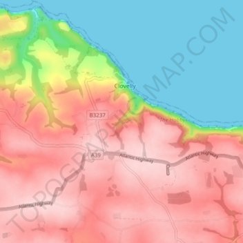
Name: Clovelly topographic map, elevation, terrain.

Location: Clovelly, Torridge District, Devon, England, United Kingdom (50.96694 -4.43599 51.01490 -4.36433)

Average elevation: 118 m

Minimum elevation: 0 m

Maximum elevation: 218 m

Devon trails, hiking, mountain biking, running and outdoor activities

Other topographic maps

Click on a map to view its topography, its elevation and its terrain.

Stoke

United Kingdom > England > Devon > Torridge District > Hartland

Average elevation: 76 m

Derril

United Kingdom > England > Devon > Torridge District > Pyworthy

Average elevation: 127 m

Ashmill

United Kingdom > England > Devon > Torridge District > Ashwater

Average elevation: 156 m

Riddlecombe

United Kingdom > England > Devon > Torridge District

Average elevation: 156 m

Clawton

United Kingdom > England > Devon > Torridge District

Average elevation: 128 m

Stibb Cross

United Kingdom > England > Devon > Torridge District

Average elevation: 157 m

Earthquake

United Kingdom > England > Devon > Torridge District

Average elevation: 35 m

Taddiport

United Kingdom > England > Devon > Torridge District

Average elevation: 85 m

High Bullen

United Kingdom > England > Devon > Torridge District

Average elevation: 147 m

Horns Cross

United Kingdom > England > Devon > Torridge District

Average elevation: 112 m