
San Rafael topographic map
Interactive map
Click on the map to display elevation.
About this map
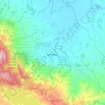
Name: San Rafael topographic map, elevation, terrain.
Average elevation: 266 m
Minimum elevation: 32 m
Maximum elevation: 1,257 m
Other topographic maps
Click on a map to view its topography, its elevation and its terrain.
Rio Celeste
Costa Rica > Cantón Guatuso > Katira > Llano Bonito 2
Rio Celeste, Llano Bonito 2, Katira, Cantón Guatuso, Provincia de Alajuela, 21504, Costa Rica
Average elevation: 112 m
Pejibaye
Costa Rica > Cantón Guatuso > Cote
Pejibaye, Cote, Cantón Guatuso, Provincia de Alajuela, 21503, Costa Rica
Average elevation: 283 m
El Silencio
Costa Rica > Cantón Guatuso > San Rafael
El Silencio, San Rafael, Cantón Guatuso, Provincia de Alajuela, 21501, Costa Rica
Average elevation: 111 m