
Rosières topographic map
Interactive map
Click on the map to display elevation.
About this map
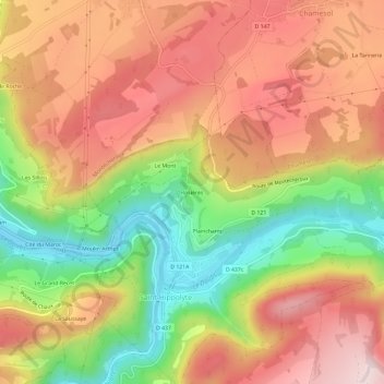
Name: Rosières topographic map, elevation, terrain.
Average elevation: 587 m
Minimum elevation: 362 m
Maximum elevation: 773 m
Other topographic maps
Click on a map to view its topography, its elevation and its terrain.
Le Mont
France > Bourgogne-Franche-Comté > Doubs > Saint-Hippolyte
Le Mont, Saint-Hippolyte, Montbéliard, Doubs, Bourgogne-Franche-Comté, France métropolitaine, 25190, France
Average elevation: 586 m
Plainchamp
France > Bourgogne-Franche-Comté > Doubs > Saint-Hippolyte
Plainchamp, Saint-Hippolyte, Montbéliard, Doubs, Bourgogne-Franche-Comté, France métropolitaine, 25190, France
Average elevation: 584 m