
Serre topographic map
Interactive map
Click on the map to display elevation.
About this map
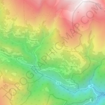
Name: Serre topographic map, elevation, terrain.
Location: Serre, Ostana, Coni, Piémont, Italie (44.67908 7.16615 44.71908 7.20615)
Average elevation: 1,530 m
Minimum elevation: 823 m
Maximum elevation: 2,268 m
Other topographic maps
Click on a map to view its topography, its elevation and its terrain.