
Thank you for supporting this site ❤️
Make a donation
Make a donation
Gear up for your next adventure:
As an Amazon Associate, this site earns from qualifying purchases at no extra cost to you.
Bricia topographic map
Click on the map to display elevation.
Thank you for supporting this site ❤️
Make a donation
Make a donation
Gear up for your next adventure:
As an Amazon Associate, this site earns from qualifying purchases at no extra cost to you.
About this map
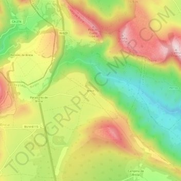
Name: Bricia topographic map, elevation, terrain.
Location: Bricia, Alfoz de Bricia, Burgos, Castile and León, Spain (42.89502 -3.83934 42.93502 -3.79934)
Average elevation: 979 m
Minimum elevation: 781 m
Maximum elevation: 1,179 m
Thank you for supporting this site ❤️
Make a donation
Make a donation
Gear up for your next adventure:
As an Amazon Associate, this site earns from qualifying purchases at no extra cost to you.