Geolocate

Farmington topographic map

Click on the map to display elevation.

About this map
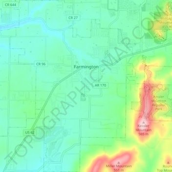
Name: Farmington topographic map, elevation, terrain.

Location: Farmington, Washington County, Arkansas, 72730, United States (35.99986 -94.28503 36.06862 -94.22387)

Average elevation: 393 m

Minimum elevation: 335 m

Maximum elevation: 567 m

Other topographic maps

Click on a map to view its topography, its elevation and its terrain.

Durham

United States > Arkansas > Washington County

Average elevation: 411 m

Sonora

United States > Arkansas > Washington County

Average elevation: 388 m

Pinnacle

United States > Arkansas > Washington County

Average elevation: 360 m

Wyman

United States > Arkansas > Washington County

Average elevation: 377 m

Canehill

United States > Arkansas > Washington County

Average elevation: 446 m

Savoy

United States > Arkansas > Washington County

Average elevation: 348 m

Sunset

United States > Arkansas > Washington County

Average elevation: 628 m

Brentwood

United States > Arkansas > Washington County

Average elevation: 513 m

Evansville

United States > Arkansas > Washington County

Average elevation: 376 m

Strickler

United States > Arkansas > Washington County

Average elevation: 486 m

Hogeye

United States > Arkansas > Washington County

Average elevation: 414 m

Gear up for your next adventure:

🧗Locking Carabiners - Secure gear to your pack or for light technical use
🛌Sleeping Bags - Warm and packable sleeping bags for outdoor nights
⛺Lightweight Tents - Compact tents for backpacking and trekking
👟Women's Trail Running Shoes - Agile footwear for fell running and technical trails
🕶️Polarized Sunglasses - Reduces glare from snow and water when reading terrain

As an Amazon Associate, this site earns from qualifying purchases at no extra cost to you.