
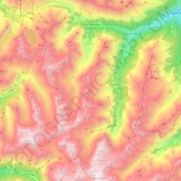
Gemeinde Sankt Sigmund im Sellrain topographic map
Interactive map
Click on the map to display elevation.
About this map
Name: Gemeinde Sankt Sigmund im Sellrain topographic map, elevation, terrain.
Average elevation: 2,289 m
Minimum elevation: 928 m
Maximum elevation: 3,268 m
Other topographic maps
Click on a map to view its topography, its elevation and its terrain.
Brennerpass
Österreich > Tirol > Bezirk Innsbruck-Land > Gemeinde Gries am Brenner > Brenner
Brennerpass, Brenner, Gemeinde Gries am Brenner, Bezirk Innsbruck-Land, Tirol, 6156, Österreich
Average elevation: 1,635 m
Weidach
Österreich > Tirol > Bezirk Innsbruck-Land > Gemeinde Leutasch
Weidach, Gemeinde Leutasch, Bezirk Innsbruck-Land, Tirol, 6105, Österreich
Average elevation: 1,299 m
Gemeinde Seefeld in Tirol
Österreich > Tirol > Bezirk Innsbruck-Land
Gemeinde Seefeld in Tirol, Bezirk Innsbruck-Land, Tirol, 6100, Österreich
Average elevation: 1,303 m