
Pisaq National Archaeological Park topographic map
Interactive map
Click on the map to display elevation.
Pisaq National Archaeological Park
The town is located in the district of Pisac, province of Calca at the southern end of the Sacred Valley at an altitude of 2,972 metres (9,751 ft), 32 kilometres (20 mi) northeast of Cusco. The town straddles the Vilcanota River with most of the settlement on its right bank, where it is laid out in a grid pattern, centred around the Plaza Constitución (formerly the Plaza de Almas). The Plaza Constitución was for many years dominated by a large pisonay tree until it was destroyed by a 2013 thunderstorm.
About this map
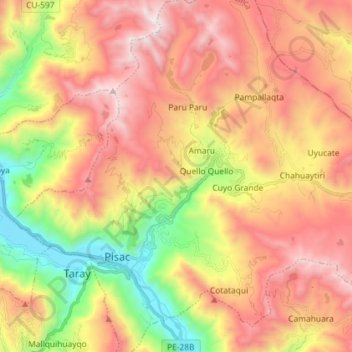
Name: Pisaq National Archaeological Park topographic map, elevation, terrain.
Average elevation: 3,848 m
Minimum elevation: 2,944 m
Maximum elevation: 4,667 m
Other topographic maps
Click on a map to view its topography, its elevation and its terrain.