
Horseshoe Bay topographic map
Interactive map
Click on the map to display elevation.
About this map
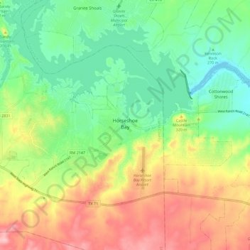
Name: Horseshoe Bay topographic map, elevation, terrain.
Location: Horseshoe Bay, Llano County, Texas, 78657, United States (30.51271 -98.43133 30.57459 -98.31902)
Average elevation: 290 m
Minimum elevation: 224 m
Maximum elevation: 387 m
Other topographic maps
Click on a map to view its topography, its elevation and its terrain.
Enchanted Rock
United States > Texas > Llano County
Enchanted Rock, Llano County, Texas, United States
Average elevation: 453 m
Kingsland
United States > Texas > Llano County
Kingsland, Llano County, Texas, 78639, United States
Average elevation: 263 m