
Konz topographic map
Click on the map to display elevation.
About this map
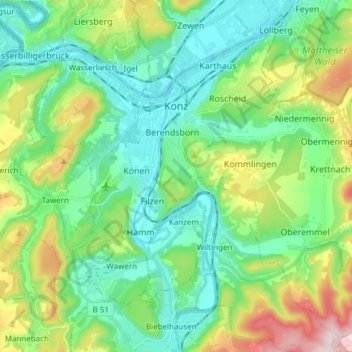
Name: Konz topographic map, elevation, terrain.
Location: Konz, Landkreis Trier-Saarburg, Rhineland-Palatinate, Germany (49.63408 6.51971 49.72394 6.67117)
Average elevation: 232 m
Minimum elevation: 122 m
Maximum elevation: 516 m
Other topographic maps
Click on a map to view its topography, its elevation and its terrain.
Heldberg
Germany > Rhineland-Palatinate > Landkreis Trier-Saarburg > Klüsserath
Average elevation: 215 m
Pellenberg
Germany > Rhineland-Palatinate > Landkreis Trier-Saarburg > Merzkirchen
Average elevation: 347 m