Geolocate

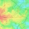
Wake Green topographic map

Click on the map to display elevation.

About this map
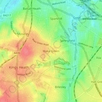
Name: Wake Green topographic map, elevation, terrain.

Location: Wake Green, Birmingham, West Midlands, England, B13 9JN, United Kingdom (52.42059 -1.89086 52.46059 -1.85086)

Average elevation: 137 m

Minimum elevation: 108 m

Maximum elevation: 169 m

England trails, hiking, mountain biking, running and outdoor activities

Other topographic maps

Click on a map to view its topography, its elevation and its terrain.
Sutton Park

United Kingdom > England > Birmingham > Four Oaks

Average elevation: 145 m

Sutton Coldfield

United Kingdom > England > Birmingham

Average elevation: 124 m

Lifford Reservoir

United Kingdom > England > Birmingham > Lifford

Average elevation: 150 m

Highbury Park

United Kingdom > England > Birmingham > Kings Heath

Average elevation: 142 m

Pype Hayes

United Kingdom > England > Birmingham > Tyburn

Average elevation: 104 m

North Edgbaston

United Kingdom > England > Birmingham

Average elevation: 162 m

Joy's Wood

United Kingdom > England > Birmingham > Wake Green

Average elevation: 140 m

Calthorpe Park

United Kingdom > England > Birmingham > Highgate

Average elevation: 128 m

Sutton Coldfield

United Kingdom > England > Birmingham

Average elevation: 124 m

Sutton Park

United Kingdom > England > Birmingham > Four Oaks

Average elevation: 145 m

Gear up for your next adventure:

🔥Emergency Fire Starters - Reliable ignition tools for survival situations in damp conditions
🧺Ultralight Dry Bags - Organize and waterproof your gear inside your rucksack
🔋Solar Power Banks - Keep your GPS and phone charged during multi-day expeditions
🧘Folding Sit Mats - Dry and warm seat for map-reading breaks on damp ground
🥤Collapsible Water Bottles - Save space in your rucksack as you consume your water

As an Amazon Associate, this site earns from qualifying purchases at no extra cost to you.