
Make a donation
Gear up for your next adventure:
As an Amazon Associate, this site earns from qualifying purchases at no extra cost to you.
Belvidere topographic map
Click on the map to display elevation.
Make a donation
Gear up for your next adventure:
As an Amazon Associate, this site earns from qualifying purchases at no extra cost to you.
Belvidere
Belvidere developed on both sides of the Kishwaukee River in north central Illinois. It is 76 miles from downtown Chicago on Routes 20, 76 and the Northern Illinois Toll road. Belvidere is an industrial community surrounded by prosperous farms. It is the County Seat with an estimated 2006 county population of over 52,000. The altitude is 800 feet above sea level, average temperatures are: 73 degrees F in the summer; 24 degrees F in the winter, and the average rainfall is 33.3 inches, and the average annual snowfall is 35.3 inches.
Make a donation
Gear up for your next adventure:
As an Amazon Associate, this site earns from qualifying purchases at no extra cost to you.
About this map
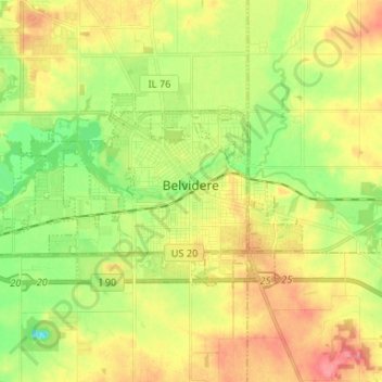
Name: Belvidere topographic map, elevation, terrain.
Average elevation: 244 m
Minimum elevation: 208 m
Maximum elevation: 282 m
Make a donation
Gear up for your next adventure:
As an Amazon Associate, this site earns from qualifying purchases at no extra cost to you.
Other topographic maps
Click on a map to view its topography, its elevation and its terrain.