
Make a donation
Gear up for your next adventure:
As an Amazon Associate, this site earns from qualifying purchases at no extra cost to you.
Mount Elgin topographic map
Click on the map to display elevation.
Make a donation
Gear up for your next adventure:
As an Amazon Associate, this site earns from qualifying purchases at no extra cost to you.
About this map
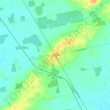
Name: Mount Elgin topographic map, elevation, terrain.
Average elevation: 281 m
Minimum elevation: 270 m
Maximum elevation: 304 m
Make a donation
Gear up for your next adventure:
As an Amazon Associate, this site earns from qualifying purchases at no extra cost to you.
Other topographic maps
Click on a map to view its topography, its elevation and its terrain.
South-West Oxford
Canada > Ontario > Oxford County > South-West Oxford
In its wilderness state, the former Dereham township had thousands of acres of swamp and marsh land which limited its use for agriculture. Several large drainage projects brought great improvement and remain as essential parts of the township's farmland infrastructure. The township topography still has several…
Average elevation: 281 m