
Brunswick topographic map
Click on the map to display elevation.
About this map
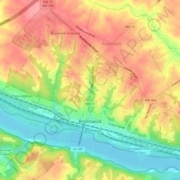
Name: Brunswick topographic map, elevation, terrain.
Location: Brunswick, Frederick County, Maryland, United States (39.30245 -77.65068 39.33683 -77.60239)
Average elevation: 118 m
Minimum elevation: 64 m
Maximum elevation: 163 m
Other topographic maps
Click on a map to view its topography, its elevation and its terrain.
Highland
United States > Maryland > Frederick County
The majority of the downtown Highland district is situated within the 418-acre (169 ha) land grant named "Hickory Ridge". The Rouse Company borrowed the land grant name for one of its nearby villages of Columbia, built in 1974. The historic "White Hall" or "Hickory Ridge" estate (1749) was owned by the…
Average elevation: 357 m
Catoctin Mountain
United States > Maryland > Frederick County
Catoctin Mountain traverses Frederick County, Maryland and extends into northern Loudoun County, Virginia. It rises to its greatest elevation of 1,900 feet (580 m) above sea level just southwest of Cunningham Falls State Park and is transected by gaps at Braddock Heights (Fairview Pass), Point of Rocks on the…
Average elevation: 471 m
Highland
United States > Maryland > Frederick County
The majority of the downtown Highland district is situated within the 418-acre (169 ha) land grant named "Hickory Ridge". The Rouse Company borrowed the land grant name for one of its nearby villages of Columbia, built in 1974. The historic "White Hall" or "Hickory Ridge" estate (1749) was owned by the…
Average elevation: 357 m
West Frederick Highlands
United States > Maryland > Frederick County > Ballenger Creek
Average elevation: 113 m
Colonial Heights
United States > Maryland > Frederick County > Thurmont > Colonial Heights
Average elevation: 157 m
Mount Airy Estates
United States > Maryland > Frederick County > Mount Airy Estates
Average elevation: 161 m