
Make a donation
Gear up for your next adventure:
As an Amazon Associate, this site earns from qualifying purchases at no extra cost to you.
Monte Cristallo topographic map
Click on the map to display elevation.
Make a donation
Gear up for your next adventure:
As an Amazon Associate, this site earns from qualifying purchases at no extra cost to you.
About this map
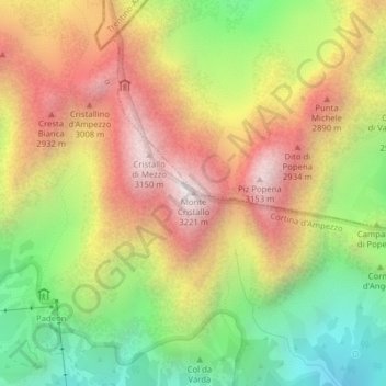
Name: Monte Cristallo topographic map, elevation, terrain.
Location: Monte Cristallo, Cortina d'Ampezzo, Belluno, Veneto, Italia (46.57540 12.20049 46.57550 12.20059)
Average elevation: 2,465 m
Minimum elevation: 1,797 m
Maximum elevation: 3,134 m
Make a donation
Gear up for your next adventure:
As an Amazon Associate, this site earns from qualifying purchases at no extra cost to you.
Other topographic maps
Click on a map to view its topography, its elevation and its terrain.
Tofane
Italia > Veneto > Belluno > Cortina d'Ampezzo
Costruita nella seconda metà del XX secolo e divisa in tre tronconi, la funivia Freccia nel Cielo è il più diretto mezzo di trasporto per raggiungere la cima della Tofana di Mezzo. La base (1.250 m s.l.m.), o prima stazione, si trova infatti nel pieno centro di Cortina, proprio davanti al famoso Stadio…
Average elevation: 2,295 m